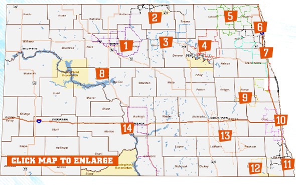
[ Snowmobile North Dakota Home Page ]

News

General Info
   About Us
   Officers
   Join SND
   Sno-Dak News
   Grant Program
   Scholarship

Resources
   Message Board
   Trails
   Calendar
   Forms
   Safety Courses
   Guidelines
   ND Laws

Links

Photo Gallery

Catalog

Contact Us

Snowmobile Trails

 Click on a trail to learn more about that system's details and current weather conditions.  Or, read and post comments in the forums.

Mandated by the state legislature, North Dakota's snowmobile trails can be open from December 1st to April 1st of each season.   A total of 14 trail systems exist in the state maintaining 2,853 miles of snowmobile trail.  After December 1st, if the trail systems meet the required guidelines for snow conditions and signing, trails are approved to open.  To learn more information on these trails and their current conditions please click on the above map. 

North Dakota's Snowmobile Trail Conditions as of 2-4-10
Trail Conditions Hotline: 701-328-5377
Select Option 1 for Trail Reports 
The #'s behind each trail name, reflect the # to enter, to obtain the latest trail report

Cattail Trail (Steele County) #15:  Open
East Central Valley Trail (Cass County) #3:  Open
Lake Region Trail (Ramsey County) #7:  Open
Mayville-Portland Trail (Traill County) #9:  Open
Missouri Valley Trail (Burleigh & Emmons County) #18:  Open
North Central Trail (Pierce & Benson County) #13:  Southern Open/Remaining Closed
Northeast Trail (Cavalier & Pembina County) #17:  Open
Peace Garden Trail (Bottineau & Rolette County) #2:  Open
Red River North Trail (Walsh County) #5:  Open
Red River South Trail (Grand Forks County) #6:  Open
Sargent County Trail (Sargent County) #16:  Open
Sheyenne Valley Trail (Barnes & Ransom County) #4:  Open
Sno-Trails (McHenry County) #12:  Open
Southern Valley Trail (Richland County) #14:  Open

Trail Conditions Note:
After selecting a trail system on the above map, please note that the trail conditions are listed in the first post in each of the trail system's message board.  The date of the post listed at the top is the date the initial post was created, the Updated date above the trail and snow conditions is the date the information was updated. 

Downloadable Maps
Select the above link for downloadable state maps.

Interactive Map Services!
Snowmobile North Dakota & the North Dakota Motor Vehicle Department have worked in cooperation with one another for the past year to place the snowmobile trails on ND's GIS Hub.  Please take the time to visit this exciting new feature and work with the interactive snowmobile trail maps.  (Note:  Please add http://web.apps.state.nd.us to the list of approved sites on your pop-up-blocker before using interactive map services.)